The Pinfold

Pinfold, in Medieval Britain, is an area originally built to hold animals which were found straying from their owners land or were found grazing on the common without common rights. The animals would not be released until a fine had been paid to the “pinder” who was an officer of the lord of the manor. Breaking into the pinfold to release the animals was an offence punishable by a fine and/or imprisonment. They were also used by drovers taking their stock to market. The pinfold was used to pen the animals overnight for a small fee.
The terms “pinfold” and “pound” are Saxon in origin. “Pundfald” and “pund” both mean an enclosure. There appears to be no difference between a pinfold and a village pound. The term pinfold seems to be more popular in the north and east of the UK whilst in the south and west the term pound is more popular.
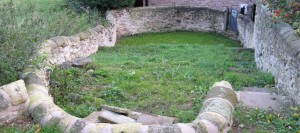
The Burghwallis Pinfold can be found in the old village at the bottom of Well Lane. The size and shape of pinfolds varies, some are four sided, rectangular, square and irregular, others are circular. Our Pinfold is approx. 8 x 9 metres and has five stone steps leading down to the bottom where a well can be found in the centre of the grounds. Pinfolds are known to date from the medieval period. By the 16th century most villages and townships would have had a pinfold. Most of what remains today would date from the 16th and 17th centuries. Some are listed buildings but most have fallen into disrepair. The Parish Council have cleared the area in preparation for planting and the surrounding stone walls have been re-pointed in limestone in keeping with regulations for this medieval site. Further work has been carried out to complete the area by volunteers from the village including re-building the well at the top of the site and laying green slate to keep the area tidy.
BURGHWALLIS
1487/0/10011 WELL LANE
17-JUN-10 Pinfold
II
Village pinfold or pound, mid C18 or earlier of limestone construction.
PLAN:
Roughly U-shaped formed at the end of a sloping lane leading from the village to the common fields. The south east corner is angled, while the south west is curved and contains an entrance. The east and west walls of the pinfold continue beyond the pinfold’s northern boundary wall flanking the lower section of the former lane.
DESCRIPTION:
The pinfold is roughly U-shaped in plan and approximately 5.7m wide. The enclosing walls are constructed of roughly-coursed limestone, with curved coping stones. The north wall, which has been strengthened by vertical orthostats and has steps at its west end, stands a few courses high and carries a modern sewerage pipe; on the south side, the walls rise to approximately 1.5m in accordance with the drop in ground level. The entrance, with a modern gate, is situated in the south west corner. There is a small stone-lined watering trough in the centre of the pinfold fed by a natural spring, and a later low stone built platform against the west wall.
HISTORY:
Documentary evidence for the presence of a pinfold at Burghwallis can be traced through the Anne family Squire record to 1753. Here the Manor Court Book states that the pinder for the period 1753 -1758 was Thomas Mallinson. He was succeeded by his wife, Dorothy, who remained in post for the next 17 years. Records from the 1780 Burghwallis Manor Court Jury provide evidence for the holding of sheep, pigs and horses or beasts. It is considered that these records refer to the present structure located adjacent to former common grazing land and a quarry, the most likely source of its building materials. The form of existing field boundaries on the 1813 Enclosure Award map are thought to indicate the location of the pinfold at the south end of an access route from the village to the common fields beyond. It is not depicted on subsequent Ordnance Survey editions presumably as it had gone out of use at enclosure.
SOURCES:
Margaret L.P. Burns `Burghwallis and Bentley: A Comparative Study of the Development of two South Yorkshire Parishes’ http://burghwallis.com/pdf/Burghwallis%20%20&%20Bentley%20Full%20&%20Maps.pdf (Accessed 20-Apr-2009)
B.M. Willmott Dobbie, `Pounds or Pinfolds, and Lockups: Beast and Man in Custody’ (Bath, 1979)
Edwin Pretty, Pinfolds in the Doncaster Borough `Yesterday Today: Doncaster’s Local History Review’ (Issue no.40 – April 2003)
REASONS FOR DESIGNATION:
The pinfold at Burghwallis is designated at Grade II for the following principal reasons:
* It is a well-preserved example of an increasingly rare building type
* For its historic interest as a surviving component of medieval open field stock management
* It is an effectively intact pre-1840 structure
* It compares favourably with other listed examples locally, with the added interest of a drinking trough.
